
ټول حقوق د منډيګک بنسټ سره محفوظ دي

Afghanistan’s leaders have often been concerned about the intentions of foreigners wanting to build railways into their country – and not without reason.
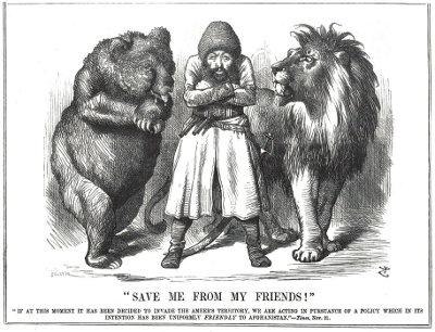
Throughout the nineteenth century the British political and military authorities were worried that Russia might advance through Afghanistan towards India, threatening British rule in the subcontinent. Even if a full-scale Russian invasion and occupation of India was unlikely, any move towards India would tie-up British resources dealing with both the Russians themselves and also any Indian uprising which they might inspire. Britain saw defence of India’s North West Frontier, now part of Pakistan, as essential to the ‘Great Game’ of politics played across Central Asia by the two rivals.
In 1857 William Andrew, Chairman of the Scinde, Punjab & Delhi Railway, suggested that railways to the Bolan and Khyber passes would have a strategic role in responding to any Russian threat.1 No action was taken until 1876, when Britain decided to keep at least one route into Afghanistan open all year round to permit the rapid deployment of troops from Karachi to counter any threat to India. Orders were given that a railway should be built to Quetta, near the Afghan border, and this developed into a scheme to reach Kandahar.
The Second Afghan War (1878-80) broke out between Britain and Afghanistan before work on the railway could begin. The war gave a new urgency to the need for easier access to the frontier, and on 18 September 1879 the Viceroy’s council decided to make do with a line through the Bolan pass usable only in fair weather. Work began just three days later, and after four months the first 215 km of the line was complete, opening from Ruk to Sibi in January 1880. On 27 March 1880 the Morning Post commented “after three and twenty years of apathy the necessity has been realised and now these railways are being constructed.” The railway was built to the 1 676 mm Indian broad gauge.
Beyond Sibi the terrain was more difficult. Reconnaissance parties had reached Kandahar by December 1879, but Afghanistan was enemy country, making it difficult to find an optimal route for the line. It was realised it would not be possible to for the railway to reach Quetta before the conclusion of the war, and so the railway was given a lower priority. When a new cabinet under Gladstone was formed in April 1880 the planned Kandahar extension was put to one side.
In March 1880 Britain and Persia agreed the Herat Convention. Persia would take control of the Afghan city of Herat subject to certain conditions, including permitting British soldiers
to be stationed there. Article seven of the draft agreement stated that
If a railway or telegraph be constructed to Kandahar the Shah [of Persia] at the request of the Queen [Victoria] would facilitate its extension to Herat in all ways in his power and would contribute thereto from the surplus of the Herat revenues according to his ability.
At first the Persian foreign minister requested the removal of this article. He eventually agreed to its inclusion, but objected to the conditions regarding the assessment of the revenue of the city.2

In 1880 Russia began to build the Trans-Caspian railway.3 In Britain there was concern that Russia might seize Herat, and extend their new railway to the city.
In response to this threat Britain restarted work on the railway to Afghanistan. To avoid alerting Russia to this work it was described as the “Harrai road improvement project”, and camels were used for construction traffic instead of the more usual temporary railway lines. This deception was abandoned when Russia occupied the city of Mary in 1883, and the line was developed as the Sind Peshin State Railway. Over 320 km long, the line reached Quetta in March 1887, through barren mountains inhabited by armed tribesmen.
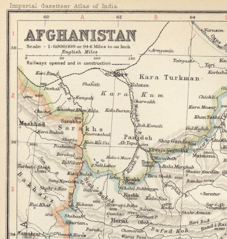
On 30 September 1891 the Chaman Extension Railway was opened, linking Bostan, north of Quetta, to the Afghan frontier. The buffer stop lay 5 km beyond Chaman fort, and just 200 m short of the Durand line, the Afghanistan-India border which was drawn around the railway when the frontier was fixed by Sir Mortimer Durand in 1893.
A supply depot was set up at Chaman containing the rails, sleepers and bridge parts required to extend the line the remaining 108 km to Kandahar in the event of a military emergency. Meanwhile, across Afghanistan, the Russians stockpiled materials at Kushka4 to allow the rapid construction of a line to Herat.
Amir Abdul Rehman, ruler of Afghanistan between 1880 and 1901, banned railways and the telegraph from entering Afghanistan, in case they were used in any British or Russian invasion. Rehman commented “there will be a railway in Afghanistan when the Afghans are able to make it themselves” and said “as long as Afghanistan has not arms enough to fight against any great attacking power, it would be folly to allow railways to be laid throughout the country.” Rehman forbade his subjects from travelling on the British line to Chaman,5 the construction of which he described as “just like pushing a knife into my vitals”.6 The Afghan army produced a manual on how to destroy railway tracks in the event of an invasion threat.7

In 1891 Captain AC Yates wrote a booklet setting out arguments in favour of building a railway to Seistan, rather than Kandahar, to allow the defence of Herat against Russia.8 “The press and the public are at this moment advocating the extension of our railways to Kandahar; but that this could be done without precipitating a rupture of our relations with the Amir is doubtful”.
اړوند پوسټونه
Around 1910 there was discussion9 regarding extending the Chaman line to Kandahar, and beyond to Herat and the Russian railhead at Kushka. In the event, the line was never extended across the border. It did however carry traffic from Afghanistan, with a daily ice-packed train bringing fresh fruit grown in Afghanistan to the cities of India until the 1940s.
A through railway link from Europe to India had long been contemplated, but the schemes raised concerns for the security of the subcontinent. In 1910 a Russian syndicate proposed a Trans-Persia railway, running from Tehran to Yezd, Kerman, Seistan and Nushki. This raised the risk of Russian troops being able to occupy Kandahar and Quetta, outnumbering available Indian army forces.
In 1911 a British study looked at the implications of Russian railway construction in the light of the successful movement of troop on the Trans-Siberian line during Russia’s war with Japan (1904-1905).10 The Trans-Persia line faced political problems “in that it would cause alarm and suspicion in Afghanistan, as its rails lead direct to the Afghan Frontier, which may give rise to tribal excitements that may prove beyond the Amir’s power to control. The measures taken to restore confidence may involve us in complications with other European Powers.”
The study’s author commented “No connection between this line and either Afghanistan or Northern Baluchistan should be permitted”,
Russian railways now stretched from Orenburg to Tashkent and Samarkand. “The further extension can only be accomplished in peace, or with the consent of the Amir, which is hardly likely to be given; or during a war with Afghanistan. The bridging of the Oxus [Amu-Darya] is estimated to take four months to complete”. It was estimated that after reaching the Amu-Darya it would take the Russians 16 months to extend the railhead to Doshi. The report also considered that an extension of the Trans-Caspian railway from Kushka into Afghan territory would only be possible with consent or in war time. Rails were stacked at Kushka, and it was estimated that the line could be laid to the Helmud in 18 months.
“The extension of Russian or Persian railways through Afghanistan should be more strongly resisted than ever” said the report. The author speculated that the German-backed Baghdad railway could be extended to the Afghan frontier, but handwritten annotations on the Public Record Office’s copy of the booklet suggest officials thought this somewhat unlikely.
The author concluded that “The present attitude of the Amir concerning them [i.e. railways] may change rapidly, as it has recently with regard to roads in Afghanistan. Thus the construction of these two lines [Trans-Caspian from Kushka, an extension from Samarkand] is probably only a matter of time.”
References
- Couplings to the Khyber PSA Berridge 1968 ↩
- England & Afghanistan Dilip Kumar Ghose 1960 ↩
- Railways At War John Westwood 1980 ↩
- Kuskha is now Serhetabat in Turkmenistan, and was also known as Gusgy in Turkmen. ↩
- Reform and Rebellion in Afghanistan 1919 – 29 Leon B Poullada ↩
- The Life of Abdur Rahman, Amir of Afghanistan, volume 2, page 159 ↩
- Afghan rail plan among proposals for donors, CNN News report, from Reuters 2002-01-21 ↩
- The Transcaspian Railway and the Power of the Russians to Occupy Herat Captain AC Yate 1891-04-29 PRO WO 106 178 ↩
- Baluchistan to Russia railway map http://users.ev1.net/~jtslrr/1910h46.jpg ↩
- Afghanistan: Military aspect of Railway communication between Europe and India – Russian aspirations towards Afghan-Turkestan 1911, PRO WO 106/58 ↩
Narrow gauge tramway near Kabul
Somewhere in the vicinity of Kabul was a narrow gauge railway which, for at least part of its length, ran down the middle of a road alongside the Kabul River. It was in existence in 1904, but so far the only information about this line that I have found comes from three almost identical photographs at the British Library.
The pictures were taken by Major Robert Bird (1866-1918) of the Indian Medical Service, who was deputed to Kabul to attend the Amir of Afghanistan Habibullah in 1904. They show just a few feet of the railway.
The captions say:1
- Photo 430/84(79) Road by Kabul River, beyond the workshops. Note the tramway to Chardchi – Cabul river through the trees – tail of Asmai Heights.
- Photo 430/84(125) Road by Cabul River beyond the workshop. Tramway in foreground.
- Photo 430/84(126) Road to *** by Cabul River. Tramway. [*** is illegible]
Unfortunately these photos are not (as far as I am aware) available online anywhere, so to see them you will need to make an appointment at the British Library.
The three photos were all taken from the same spot, and probably at the same time. They show horses and donkeys carrying loads and people along a road, including a woman with a child on a horse. What appears to be the same person is in both photo 79 and photo 125.
Sticking up in the centre of the road are some rails. Only a single track is visible, but of course there could be a second track out of shot. The road looks well maintained, but it hard to tell what the surface it. I would estimate that the railway is perhaps around 18” gauge, 2ft at the most.
The hard-to-read place name looks like it might be Indeptai, or perhaps Indebbe which is mentioned in the caption to another photo, number 76, which shows “Chouki on road to Indebbe just past the factory”.
I would assume “the workshops” refers to the Mashin Khana factory site. Asmai Heights is what is now (but presumably not in 1904!) popularly known as TV Hill from the broadcasting masts on top of it, and is not far away from the workshops.
However I can’t spot any places on maps of Kabul which have names that look like a British visitor in around 1904 might spell them as Chardchi and Indeptai. Has anyone got any ideas? There is Pul-e-Charkhi, with its prison, but that appears to be on the other side of the city to the workshops, and not by the river.
There are no obvious landmarks in the photos to help pin down the location. The road is lined with trees, with the river visible through them. Nothing is visible across the river, because the photos are over-exposed.
It is possible that the tramway was related to this:
The Amir of Kabul has ordered a survey to be made for a steam tramway, five miles in length, outside Kabul City, in order to bring stone for building purposes from the adjacent hills.
Source: News of the Week, p7, The Liberal and the New Dispensation, 9 July 1893
A similar report also appears in Electric Railway Review, Volume 3, 1893.
Any more information about this railway or the locations of Chardchi and Indeptai would be gratefully received.
References
- Curzon Collection: Views of Afghanistan and the North-West Frontier. Series of small printing-out paper prints originally contained in an envelope labelled ‘For Lord Curzon. Set of snap-shots taken by Major Bird on the way to and at Kabul.’ British Library shelfmark Photo 430/84. Viewed by me on 7 March 2014 ↩
Kabul River and Loi Shilman railways
During the second Afghan war (1878-1880) Sir Guilford Molesworth considered the possibility of constructing a metre gauge railway through the Khyber Pass to Afghanistan. However, there was not yet a bridge across the River Indus, and constructing one would have been a major undertaking. In 1885 Captain JRL McDonald surveyed the feasibility of building a railway to Landi Kotal,1 and in 1890 he surveyed a route along the Kabul River gorge. In 1898 another survey was carried out for a metre or narrower gauge line through the Khyber Pass to Landi Kotal.
In 1901 the broad gauge North Western Railway was extended from Peshawar to Jamrud, and in 1905 work began on a railway along the Kabul River valley in the Mullagori hills.
Parliament authorised the construction of this line as far as Torkham, and there was heated discussion about what course should be taken. There were two potential alignments. One ran up the Loi Shilman valley as far as the Shilman Ghakki pass, while the second route followed the Kabul River to Smatsai, below the fort at Dakka. On 17 December 1904 Lieutenant-Colonel HA Deane, Agent to the Governor General and Chief Commissioner, North West Frontier Province wrote to the Secretary to the Government of India with plans and estimates for the Shilman Ghakki route.2
Commander-in-Chief Lord Kitchener supported a direct route westwards through the Loi Shilman valley, with a tunnel between Warsak and Smatsai. The tunnel was deemed to be too expensive, and so it was decided to take an easier alignment following the bend in the river to Palosi.
The Afghans considered their territory to extend for some distance on the Indian side of the artificial border of the Durand line. Which ever route the railway took, it would extend beyond British-controlled areas. Construction work was held up by local tribes launching attacks on the works. The authorities discussed how best to protect the line, and the Chief Commissioner for police and militia corps on the North West Frontier directed Major GO Roos-Keppel of the Khyber Rifles to prepare a scheme to defend two possible routes for the railway.
Major Roos-Keppel, Major Dundee of the Royal Engineers and Captains Bickford and Rouston of the Khyber Rifles discussed the matter at Landi Kotal. “The construction of the railway will undoubtedly be unpopular” Roos-Keppel wrote3 to Major WE Venour, staff officer to the Chief Commissioner on 31 May 1905.
The railway would be very exposed to attack, in particular from the north. As a result a levy corps would need to be strong and self contained, with about 1 750 rifles. The Khyber Rifles could be expanded to provide guards, and both the Khyber Pass and the Kabul River Railway could be supported from Landi Kotal, though outposts would be two or three days march over difficult terrain from the garrison. Roos-Keppel suggested that troops’ pay may have to be raised. If the line ran via the Loi Shilman valley then the Khyber Rifles would need six additional infantry companies, with 100 Sowars (cavalry). The more exposed Kabul River route would require nine infantry companies, with 100 Sowars.
The line was to be protected by blockhouses. On the Loi Shilman route the locations of the defensive points would be:
- Blockhouse 1: 1 mile north west of Shahmansur Khel, to control the Chena Gudr ferry.
- A signalling post night be required on Tor Ghar, between blockhouses 1 and 2.
- Blockhouse 2: Spur north of and immediately above Ghorangi.
- Blockhouse 3: On main spur due east of the mouth of the Loi Shilman valley.
- Blockhouse 4: 1/2 miles further north
- Blockhouse 5: On hill 1/2 miles north west of Fatteh village
- Blockhouse 6: On hill 1/6 mile north of Kama.
- Blockhouse 7: If politically possible this would be located on the main ridge south of the pass, else it would be on a knoll about 2/3 mile south east of the Shilman Ghakki pass.
The Kabul River alignment would require Blockhouses 4, 5 and 6 to be on the left bank of the river. Number 7 blockhouse would be located either in the same place or further to the west. Two companies would be located from Shinilo Gudr to Sara Tigga. Half a company would be based at Shinpokh, half at Smatsai.
On 6 July 1905 Lieutenant-Colonel HA Deane wrote4 to the Secretary to the Government of India with “proposals for the protection of working parties during the construction of the railway and for the safeguarding of the line after completion.” Deane understood “there is a possibility of work on this railway being put in hand in the coming Autumn”.
“Apart from the question of Afghan interference, the line is open to attack from two sides:- the Afridis and other tribes on the right bank of the Kabul River and the Mohmands … on the left bank.” Construction would require “assistance not only of the Khyber tribes through whose country the railway will actually run, but also of the Mohmands who from their position on the flank and their propinquity to the railway up Sara Tigga would be enabled to cross the Kabul River and inflict damage on the line.” Because the Afridis and Mohmands were hereditary enemies, Deane did not recommend Roos-Keppel’s proposal to use the Khyber Rifles to guard the railway. Instead he recommended a moderate increase in the number of Khyber Rifles to guard the railway within the Khyber agency’s area, and the raising of a levy corps of Mohmands to hold a chain of posts from Michni to Sara Tigga.
On 15 July 1905 the British Government sent a telegram to the Government of India saying they were not satisfied that the Shilman Ghakki route was the best available. The Government of India said it would investigate further.5
Construction work began on the Loi Shilman route, and by 1907 there was 32 km of metre-gauge some broad gauge line in place from Kacha Garhi on the railway to Jamrud, to Warsak. The line was to run along the Kabul River valley and then westwards towards the Loi Shilman valley.6 The Flying Afridi ran as far as Warsak in the Peshawar plain7 (not the Warsak in the Loi Shilman valley).
An alliance between Britain and Russia resulted in the Convention of St Petersburg of 31 August 1907.8 Britain would “neither to annex nor occupy” any portion of Afghanistan, and Russia declared the country to be “outside the sphere of Russian influence”. This reduced the perceived threat to India, and the Kabul River railway was dismantled in 1909 without reaching the Durand line. The track materials and bridges were recovered for reuse elsewhere.
Next page: Khyber Pass railway
References
- http://www.gre.ac.uk/~ko903/archive/webpages/khyber.htm ↩
- Mentioned in Letter from Lieutenant-Colonel HA Deane to the Secretary to the Government of India 1905-07-06 PRO 106/56 ↩
- Letter from Major GO Roos-Keppel to Major WE Venour 1905-05-31 PRO WO 106/56 ↩
- Letter from Lieutenant-Colonel HA Deane to the Secretary to the Government of India, 1905-07-06 PRO 106/56 ↩
- Proposals for raising a levy corps of Mohmands and increasing the Khyber Rifles to guard the Kabul River Railway. Letter from EHS Clarke, Deputy Secretary to the Government of India, to the Hon’ble Mr MF O’Dwyer, officiating Chief Commissioner and Agent of the Governor General in the North West Frontier Province. 1905-08-28 PRO WO 106/56 ↩
- Couplings to the Khyber PSA Berridge 1968 ↩
- Gun Running & the Indian North West Frontier Hon. Arnold Keppel 1991 ↩
- Key Treaties for the Great Powers 1814 – 1914 Vol 2 1871 – 1914 Michael Hurst (Ed.) 1972 ↩
Kabul to Darulaman railway
Abdul Rehman’s grandson Amanullah became King of Afghanistan in 1919, and began to modernise the nation. His plans included railways.
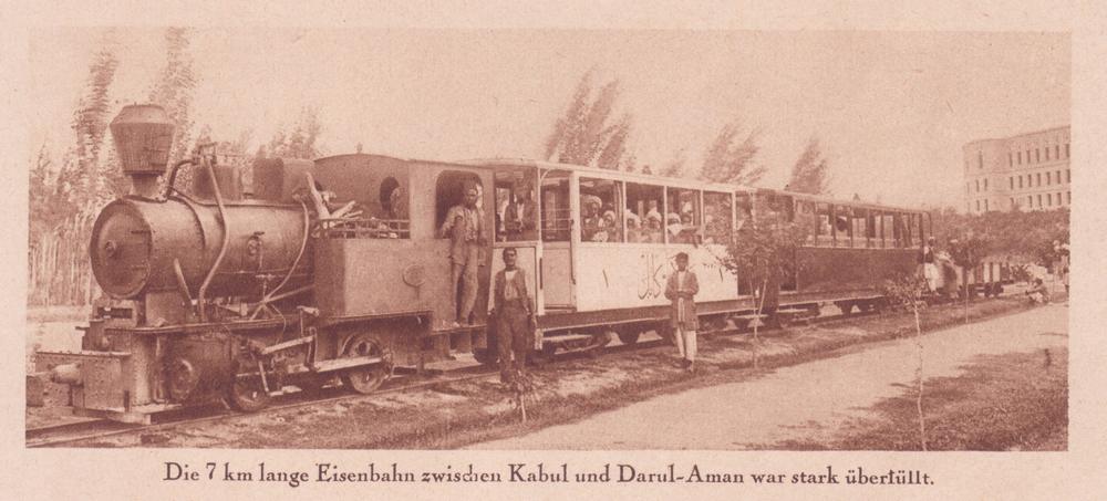
Work began on a new European-style capital city at Darulaman near Kabul.1 On 15 December 1922 The Locomotive reported “Travellers from Afghanistan state a railway is being laid down for a distance of some six miles from Kabul to the site of the new city of Darulaman, and also that some of the rolling stock for it is being manufactured in the Kabul workshops.”2

Three small steam locomotives were acquired from Henschel of Kassel in Germany, and possibly either some carriages or underframe components to use with locally-built bodies. The locos were put to work on a 7 km roadside tramway linking Kabul and Darulaman. In August 1928 The Locomotive reported “the only railway at present in Afghanistan is five miles long, between Kabul and Darulaman.”3
King Amanullah was overthrown in January 1929, and the railway fell out of use at some point. The locomotives were put into store in the two-road engine shed, then became part of the collection of the National Museum of Afghanistan.
In January 2002 museum caretaker Omara Khan Masoudi said “These are historical artefacts and we want to keep them. Of course, it would be good to have a real railway now, that would be progress”.4
A 2’6″ gauge tramway ran for about 7km from Kabul southwest to Darulaman.
Then …
Wilhelm Rieck of Berlin was in Kabul in 1923. He was one of a number of Germans who worked in Afghanistan by request of King Amanullah, and was in charge of building electrical installations, in particular at Darulaman palace.
He travelled to Kabul, Kandahar, India, and Teheran taking photographs, and his great-grandson Werner Müller sent me these two photos of the railway. The Germans also built a school, which has a website which shows some of Rieck’s photos
Despite everything, the steam locomotives have survived, at first in their shed at the Kabul museum in Darulaman, and now out in the open.
On October 13 2004 Wim Brummelman found the three locos at Darulaman, in the yard behind the museum: most sources had suggested there were only two locos. Can any one tell me what model they might be, or supply any more details?

Map courtesy of The General Libraries, The University of Texas at Austin.
References
- Dawn of another era, Railway Gazette International, August 1976, p317, accessible at University of York ↩
- The Locomotive Magazine, 1922-12-15, p379 ↩
- The Locomotive Magazine, 1928-08-15, p262 ↩
- Afghan rail plan among proposals for donors, CNN News report, from Reuters, 2002-01-21 ↩
Murghab valley railway
In 1897-98 imperial Russia built a branch line to the Afghan frontier from Merv (now Mary) on the Trans-Caspian railway.
The line ran for 293 versts (313 km) along the valleys of the Murghab and Kushk rivers to terminate at Kushkinski Post, a military outpost founded in 1890 which became the southernmost point of the Russian empire and the nucleus of the town of Kushka (now Sehetabat).
Work on the railway started on 15 November 1897, and it was opened on 4 December 1898.1 However the tracks did not cross into Afghanistan.
The new line was controlled by the Russian military, and in 1900 Russia’s Minister of War conducted an experiment in which a detachment of troops travelled by rail from Tiflis (now Tbilisi) to Baku, then by ship across the Caspian Sea to Krasnovodsk, and then by rail to Kushka. This experiment showed that troops could move from the Caucasus to the Afghan border in eight days.2
The fact that a railway 220 miles long, directly threatening Herat, Afghanistan, has been built, almost one might say secretly, is astonishing in these days of telegraph and newspapers. The line was commenced some two years ago, but all allusions to it were scoffed at in St. Petersburg.
Russia’s secret railroad, Deseret Evening News, 8 April 1899
Construction of the railway caused concern in Britain and British-ruled India.
Some Britons feared that Russia might soon extend the railway from Kushka to Herat, a major city with plentiful food and water which would be a useful staging post for any Russian military attempt to threaten India, either as an end in itself or as a way of tying up British resources to enable Russia to apply pressure against Britain in Europe or elsewhere in the world.
Some people in Britain advocated that the Indian railway to Chaman near Afghanistan’s southern border should be extended through to Kandahar. This would enable British and Indian troops to be rushed to Afghanistan to meet any perceived Russian threat, and to ensure that any fighting would be at a safe distance from British India itself.
… reflect that if the future brings war between England and Russia its roaring tide will flow over these very rails for the invasion of India, and that if it brings peace [Merv] will be a station on the through line between Calais and Kandahar.
The Russian March on India. A secret railway line, Henry Norman MP, Scribener’s Magazine, 1901
However the Afghan government — perhaps understandably — strongly opposed plans for foreigners to build railways on Afghan territory, and neither of the rival empires built lines across their frontiers.
The USSR eventually extended the railway by a short distance to serve a freight terminal which was built on the Afghan side of the border at Turghondi. I have not been able to pin down when the extension was constructed, but it was possibly in the 1960s.
Proposals for a railway extension from Chaman in Pakistan to the Afghan border town of Spin Boldak and on to the city of Kandahar are still discussed today.
References
- Хронология событий, Ministry of Railway Transport of Turkmenistan ↩
- Russia And Afghanistan. Through Reuter’s Agency. The Times, 8 Jan 1900; p4. Issue 36033, col
